For the past ten days, Syria’s coastal mountain regions have been battling one of the worst environmental disasters in recent memory. A wave of intense wildfires has swept through the forests of Lattakia Governorate, destroying vast swaths of farmland and woodland, displacing hundreds of families, and exposing the country’s vulnerable disaster-response systems—already weakened by more than a decade of war.
The fires began in early July amid a record-breaking heatwave across the eastern Mediterranean. The conditions laid bare the inadequacy of local firefighting capacities and the fragile infrastructure available to respond to natural disasters in a conflict-torn country.
Partial Containment Achieved
On Sunday morning, the Syrian Civil Defence announced that it had successfully contained most of the major fire zones in western Syria. However, firefighting teams remain on high alert, continuing to cool down hotspots and monitor for possible flare-ups driven by hot winds.
In a statement posted to its official Facebook page, the Civil Defence said the affected areas had been divided into protected sectors using improvised firebreaks carved into the forest—often under dangerous and difficult conditions—to prevent the flames from jumping across valleys and ridgelines.
According to the UN Office for the Coordination of Humanitarian Affairs (OCHA) in Damascus, the fires have scorched at least 100 square kilometres of land—approximately 10,000 hectares—a devastating blow to an area of immense ecological, agricultural, and touristic value.
Preliminary UN field assessments covering 60 population centres confirmed that hundreds of people have been displaced, dozens of homes have been destroyed, and critical infrastructure—including roads, power lines, and water tanks—has been severely damaged. The destruction has crippled livelihoods, particularly for local farmers and beekeepers.
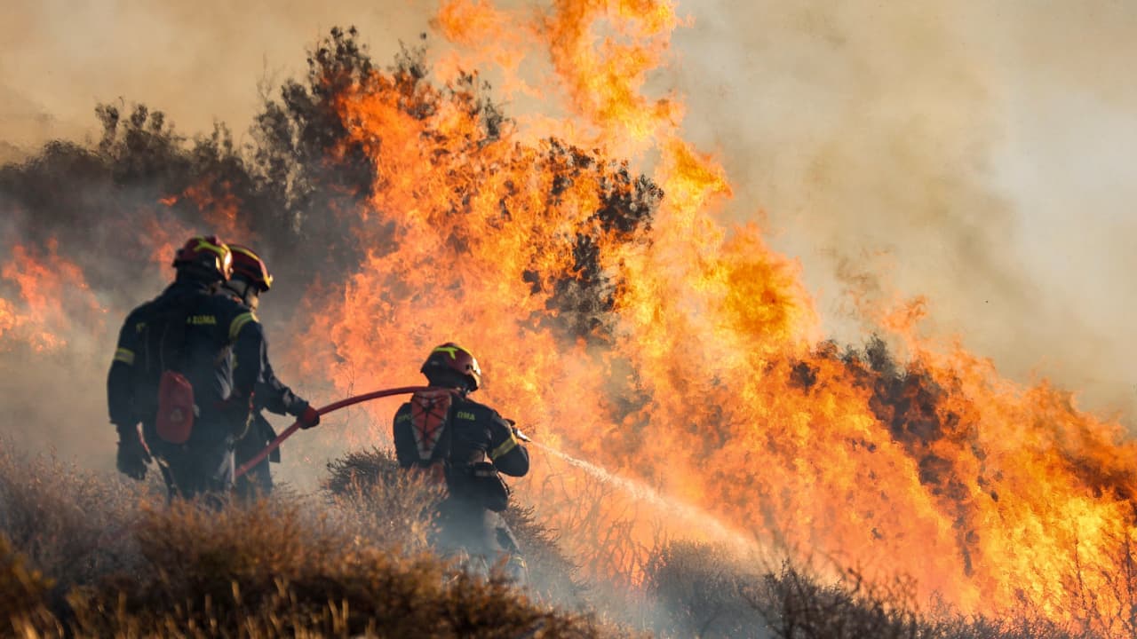
Unprecedented Mobilization and Regional Support
Despite severe logistical and meteorological challenges, Syrian firefighters managed to contain most of the blazes thanks to an unprecedented national mobilisation. More than 150 teams from the Civil Defence and Fire Brigades were deployed, supported by over 300 firefighting vehicles and additional equipment provided by government agencies and civilian volunteers.
The emergency effort also benefited from a broad regional response. Firefighting teams and aerial support arrived from Turkey, Jordan, Lebanon, Iraq, and Qatar, marking a rare instance of regional coordination in the face of a shared environmental threat. For the first time, 16 firefighting aircraft were used in joint operations to combat the flames.
According to Syria’s state-run news agency SANA, the most difficult zones were the forests of Burj Zahya, al-Furnlaq, and Naba al-Murr near Kasab—areas known for steep terrain and dense vegetation. The presence of war remnants and landmines further compounded the danger, making firefighting efforts especially perilous.
Extremely high temperatures—ranging from 40°C to 44°C over the past week—combined with strong westerly winds created ideal conditions for the fires to spread rapidly, overwhelming existing containment lines.
UN Mobilises Emergency Response
Syria’s Minister of Emergency Affairs, Raed al-Saleh, stated on the X platform that the situation is now “relatively under control” but warned that shifting winds could reignite smouldering patches. He stressed the need to continue cooling and surveillance efforts to prevent a resurgence.
In response, the UN Resident Coordinator in Syria, Adam Abdelmoula, announced an emergency allocation of $625,000 from the Syria Humanitarian Fund to support relief efforts in Lattakia. The funds will be used to provide emergency shelter, food, clean water, and support for primary healthcare services, primarily through the Syrian Arab Red Crescent and UN field partners.
Satellite Surveillance and the Call for a Fire Management Authority
To enhance situational awareness, the European Union activated the Copernicus Emergency Mapping Service, delivering real-time satellite maps to Syrian firefighting units. The maps offer high-resolution imaging down to the level of individual villages, significantly improving tactical response and resource allocation.
Despite the large-scale response, the crisis exposed chronic weaknesses in Syria’s ability to deal with large wildfires. The country lacks specialised firefighting aircraft, modern equipment, and trained personnel capable of responding to fast-moving, large-scale environmental disasters.
In light of this, environmental activists and local NGOs have renewed calls for the establishment of a national, independent wildfire management authority, equipped with modern technologies, continuous training, and sufficient funding. Such a body, they argue, is essential in a country where forests like Lattakia’s—home to oak, pine, and pistachio trees—require decades to regenerate. In wildfire prevention, they warn, preparedness is far more effective than reaction.
This article was translated and edited by The Syrian Observer. The Syrian Observer has not verified the content of this story. Responsibility for the information and views set out in this article lies entirely with the author.