Recently, reports have surfaced regarding the United States preparing to deploy its forces stationed in Syria for potential military action involving the Iraqi-Syrian border. This preparation involves strengthening the military and logistical capabilities of these forces.
Amid growing speculation surrounding these reports, the “ICAD” platform, specializing in open-source investigations, has unveiled significant recent developments and reinforcements observed at the al-Tanf border base. This base represents the most critical and largest US military presence in the Syrian desert. The platform conducted a thorough investigation, utilizing satellite imagery and various available technologies.
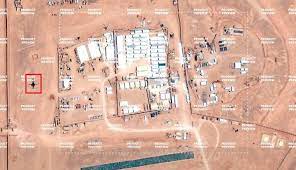
ICAD initiated its investigation by examining satellite images of the military base using Google Earth Pro. It was found that the most recent imagery available was dated June 18, 2022. These images were then compared to clearer images obtained from the Maxar platform, which were captured in early August. ICAD decided to present these findings to the public for the first time.
The investigative team documented their findings in a series of tweets. In their initial comparison of the two images, spanning from one year apart to just six weeks apart, they noted the emergence of new fortifications at the base and expansions in hardware and infrastructure.
Syria Accuses U.S. of Continuing Resource Exploitation and Calls for Accountability
Additionally, they acquired low-resolution satellite imagery from the Sentinel Hub, which illustrated the chronological development at the Tanf base from June 2022 to August 2023. In the June 2022 Sentinel Hub images, the base covered an area of 1.45 square kilometres with a perimeter of 5.15 kilometres. In contrast, the recent Maxar images showed an expanded area of 1.86 square kilometres and a perimeter of 5.91 kilometres. This indicates a growth of 0.41 square kilometres in area and an increase of approximately 0.76 kilometres in the perimeter.
The changes observed at the base primarily focused on enhancing the depth of earth mounds and barricades surrounding it, suggesting a heightened emphasis on security by the American forces. The comparison of images also revealed an increased use of camouflage nets and protective measures on various base buildings and facilities.
Notably, the new images indicated that Washington had supplied the base with new equipment, including the Persistent Threat Detection System—a large white airship capable of gathering intelligence within a range of up to 100 miles in all directions, around the clock.
While analyzing the satellite imagery, the team also noted several alterations in the base’s infrastructure. These changes included the construction of a new entrance in the northwest, complete with a paved road and a “roundabout” to regulate traffic flow. As a result, the base now boasts two entrances, as opposed to its previous sole entrance in the south. Furthermore, four large buildings with a combined area of 2,400 square meters were constructed at the center of the base, likely serving as equipment storage or accommodation for soldiers. This suggests the possibility of new military reinforcements being stationed at the base.
This article was translated and edited by The Syrian Observer. The Syrian Observer has not verified the content of this story. Responsibility for the information and views set out in this article lies entirely with the author.